
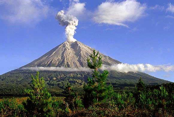
The position of this mountain is located between the administrative area Malang and Lumajang, with geographical position between 8 ° 06 'latitude and 120 ° 55' east longitude. Mahameru Peak is the peak of Mount Semeru, the highest mountain on the island of Java and the second highest volcano in Indonesia and one of the most active volcanoes. Mahameru Peak is a mountain located on the island of Java, Indonesia. Mahameru peak located at an altitude of 3.676 meters above sea level. Mahameru Peak Hill dipterocarp forest surrounded, Upper dipterocarp forest, Montane forest, and mountain or forest Ericaceous Forest.

Each approximately 20 minutes once a crater Mahameru issue is black volcanic ash and sand material. Crater Jongring Saloka, thus the name of this crater in 1913 and in 1946 filled a crater dome. On the south, the dome breaking edge of the crater caused lava flows south of the area gets Pasirian, Candiputro, and Lumajang. Viewed from a distance Mahameru showed a perfect cone shape, but when you are on top of the mountain is a large dome-shaped with a field heave at every ridge.

Peak Mahameru is the youngest part of the Mountains Jambangan but has developed into a large strato-volcano separate. Activities volcanic material released include: - The eruption of ash, lava bombs old and young lava bombs - Materials volcanic lava mixed with rain water or river water. - The eruption of the cone that causes avalanches. - Pertunbuhan slow / gradual than a grain of lava and glowing hot lava a few times.
As generally in other high places, regions along the travel route from the village of Ranu Pane (2.200m asl) to the Peak Mahameru have relatively cool temperatures. The average temperature ranges between 3 ° c - 8 ° c at night and early morning, whereas during the day ranged between 15 ° c - 21 ° c. Sometimes in Ranu Kumbolo and Kalimati occurred small snowfall that occurs during the rainy season changes to dry season or vice versa. Cold temperatures along the route of this trip is not solely caused by the still air but are supported by the wind which blows into this area causes the air gets colder.

The first person to climb this mountain is Clignet (1838), a Dutch geologist from the southwest through Widodaren, then Junhuhn (1945) a Dutch botanist from the north via the Mount Ayet-Ayek, Hill-Inder Inder, and Hill Kepolo. 1911, Van Gogh and Heim through northern slope. After 1945 are generally carried out through the north slope ascent through the village of Ranupane later, through Ranu Kumbolo today.


Tidak ada komentar:
Posting Komentar